Item request has been placed! ×
Item request cannot be made. ×
loading  Processing Request

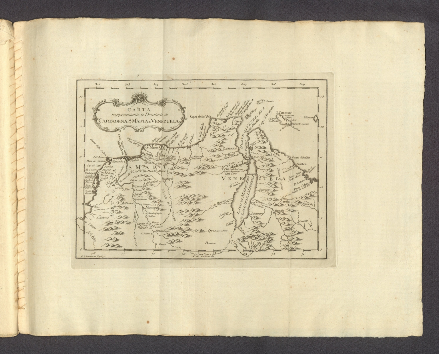
Carta rappresentante le Provincie di Cartagena S. Marta e Venezuela. D. Veremondo Rossi fe.
Atlante dell'America contenente le migliori carte geografiche, e topografiche delle principali città, laghi, fiumi, e fortezze del nuovo mondo con una succinta Relazione dei diversi Stabilimenti Europèi in quella parte di Globo, e principalimente dei Luoghi, che servono adesso di Teatro alla present Guerra fra i Coloni Inglesi, e la Madre Patria. Livorno MDCCLXXVII. Presso Gio. Tommaso Masi, e. comp. Con approvazione.
Carta rappresentante le Provincie di Cartagena S. Marta e Venezuela.

Item request has been placed! ×
Item request cannot be made. ×
loading   Processing Request
  • Additional Information
    • Publication Information:
      Masi, Giovanni Tommaso, 1777.
    • Publication Date:
      1777
    • Collection:
      David Rumsey Historical Map Collect
    • Subject Terms:
    • Abstract:
      Map of Venezuela, including present-day areas of Cartagena and Santa Maria, Colombia. Shows cities, ports, topography, drainage, coastlines, and islands. Relief shown pictorially. Includes latitudinal and longitudinal lines. Black and white engraving, with title in decorative cartouche. Map is 20 x 28 cm, on fold-out sheet 37 x 47 cm. Descriptive text for map appears on page 13 of Dexcrizione delle carte geografiche, which precedes maps.
      Atlante dell'America, published by Giovanni Tommaso Masi in Livorno, 1777. Title translates to: Atlas of America. Bound in original paper boards (front cover and first quire detached). Folio format. Collation: [1] leaf of plates, 15 pages, [44] leaves of plates (25 double). Engraved frontispiece, vignette on title page, and headpiece decorating descriptive text. Maps preceded by a publisher’s preface, as well as collocated text describing each, except for the view, Quebec. Volume comprised of 44 leaves of plates, which include 39 maps and 5 views. Maps show political boundaries, cities, fortifications, roads, canals, ports, topography, vegetation, drainage, coastlines, shoals, islands and water depths. Black and white engravings. First separate edition of this Atlas of the Americas, issued on the advent of the American Revolution. The maps and text in this atlas were first issued during the French and Indian War, in Il Gazzettiere Americano, published by M. Coltenllini in Livorno in 1763. The text for that work was translated from the 1763 London American Gazeteer. Masi republished this section of that work in 1777, as interest in the Americas increased during the American Revolution. Provenance: prior ownership indicated by inscription of Andrea Verrazzani, dated 1827, on front cover.
      Phillips 1167
    • Accession Number:
      edsluc.RUMSEY.8.1.336420.90104135